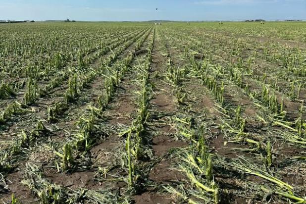
Several crops in the area, like this cornfield southwest of Holyoke, were severely damaged by a brutal storm that swept through the area last Wednesday night. — Photo courtesy of Briana Worley

Many houses in the area sustained significant damage like this one southwest of Holyoke from a hailstorm that hit the area last week. — Photo courtesy of Alyssa Gertner
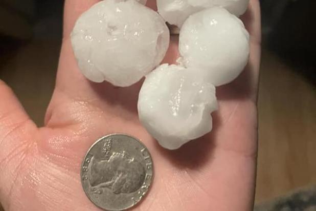
A Wednesday evening storm brought hail upwards of 1.5 inches in diameter, causing considerable damage to area crops and structures. — Photo courtesy of Brittany Dirks
Wheat destroyed, corn and sugar beets damaged by storm
Northeastern Colorado, including Phillips County and the town of Holyoke, were walloped last week by bad weather. So much so that fields of various crops were destroyed, or nearly destroyed, and houses and other structures severely damaged.
“It was devastating for the crops, especially south and east of Holyoke,” said Perry Campbell from CHS High Plains in Amherst. “Many of the fields will probably be zeroed out.”
According to the Boulder National Weather Service’s website, very large hail stretched over a wide swatch of northeast Colorado during June 27 and 28.
“Hail sizes from 2.5” to 4” in diameter occurred over an area from Fort Morgan to Akron to Otis. In additional very large hail occurred over portions of Logan and Phillips counties,” according to the outlet’s website.
Campbell said it was the combination of the wind and the hail that was the most devastating to crops.
He said at times, small, pea-sized hail, and upwards of 1.5” in diameter hail, driven by 80-plus mph winds, was too much for crops to handle.
“The crops in many areas were just shredded,” he said.
He said crops in their final stages of development, especially wheat, will not come out of the damage, while some of the corn fields might.
“We won’t know for more than a couple of weeks if the corn will come out of this, but the sugar beets will most likely come back,” he said. “There are a lot of farmers down in the dumps, that’s for sure.”
According to Jason Frost of CHS High Plains in Holyoke, the wind gusts were extremely bad at times, with some of his customers saying they believe what they experienced was a microburst or macroburst. The difference between the two is the area that is covered by the weather event, according to the National Weather Service’s website.
A macroburst or microburst is a localized column of sinking air (downdraft) within a thunderstorm that can cause extensive damage at the surface, and in some instances, can be life-threatening. Wind speeds in a macro- or microburst can reach up to 100 mph, or even higher, which is equivalent to an EF-1 tornado, according to the website.
Neither Campbell nor Frost knew exactly how many acres of crops were affected in the weather event when contacted late on Friday, June 30, but thought they would have a better idea toward the end of the first week of July.
Several attempts by the Enterprise to contact the Phillips County Emergency Management Office to find out the extent of the damage to homes and businesses in the area went unanswered, with the information not available at press time.